What you need to know about subdividing your property
If you want to create a new title or change the boundaries of an existing title this is known as being a subdivision of land.
Any subdivision requires a resource consent approval under the Ōtorohanga District Plan. To subdivide you will need to engage the services of a professional (e.g. registered surveyor) to prepare an application to Council and to help you through the subdivision process.
Council staff cannot design or prepare your subdivision application. The role of Council is to assess the application, make a decision to decline or grant consent and place conditions on the subdivision.
Whether or not you can subdivide will depend on where your property is located within the Ōtorohanga District.
Rural Area
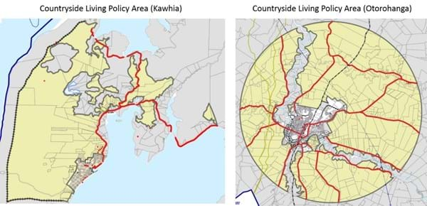
In the Rural Area Council policy is to restrict subdivision to boundary relocations or the creation of one additional title where properties have a land area of 20 hectares or more and the record of title was created before September 2010. The exception to this is the Countryside Living Policy Area surrounding Ōtorohanga and Kāwhia where rural residential subdivision can be undertaken.
If your property is located in an area which is identified by the Planning Maps as Coastal or Landscape Policy Area or an area affected by natural hazards then other restrictions on subdivision may apply.

Urban Area (Ōtorohanga)
Within parts of Ōtorohanga township that have access to the public sewerage system subdivision can take place reasonably easily where lot sizes of 500m2 or larger are proposed. If smaller lot sizes are proposed then you will be required to demonstrate how either an existing or proposed dwelling can be contained on the lot that complies with the development control standards in the District Plan (e.g. yard setbacks, site coverage, parking, stormwater management).
Urban Area (Kāwhia)
As there is no public sewerage system in Kāwhia, subdivision to smaller lot sizes is more difficult. A minimum lot size of 2500m2 applies to Kāwhia. If smaller lot sizes are proposed then you will be required to demonstrate if the lots will be able to be served by an existing or proposed on-site sewerage system that complies with the requirements of the Waikato Regional Plan.
Information Requirements
Your subdivision proposal needs to be shown on a drawn to scale plan. This plan will be prepared by your surveyor as part of the application.
The District Plan sets out what needs to be shown on the subdivision plan. Generally we will need to know:
- Size of proposed lots
- How each lot will get vehicle access (including sight visibility from entranceways)
- Location of existing buildings, water supply lines, and service connections
- Location of existing / proposed easements
- Potential building platforms
- Any areas of natural hazards (flooding / unstable ground / fill areas)
- Location of known archaeological sites
As part of any subdivision you may also be required to provide:
- Confirmation from service suppliers that proposed lots can be connected to electricity / telecommunications
- Written comments from New Zealand Transport Agency if access is from a state highway
- Geotechnical report to confirm building platform suitability
- Information on soil contamination
- Written comments from local iwi
- Written consents from neighbouring landowners and occupiers
Engaging a surveyor to undertake a feasibility report can help you understand the process and whether your idea is practical or not. They may even be able to recommend alternatives where appropriate.
Getting a surveyor on board early on in the process can be a good way to minimise risks before taking the next steps.
Subdivision Requirements
In making a decision on your application Council has the ability to impose conditions. In most cases you will be required to complete all works required by conditions before you can complete the subdivision and create the new titles.
These conditions may require:
- construction and upgrading of entranceways and rights of way
- construction of roads
- granting / reserving of easements
- connection to public water, sewerage and stormwater systems and electricity / telecommunications services
- provision for on-site stormwater management
- submission of engineering design plans
- Payment of reserve and development contributions
- Provision of esplanade reserves / strips
The type and nature of the conditions will depend on the location of you property, scale of the subdivision and the number of lots proposed.
Subdivision Costs
In addition to the costs of complying with consent conditions you will also be required to meet all of Councils actual and reasonable costs incurred in processing the application and approving compliance with conditions. View our fees and charges for costs.
Other costs will include:
- Surveyor costs
- Your lawyers fees for conveyancing
- Land Information New Zealand Fees
Total costs will vary on a case by case basis depending on the nature of conditions attached to the subdivision consent and the scale of the subdivision.
Still interested in subdividing?
Generally your first step will be to engage a surveyor to commence the subdivision process. They will be able to inform you of whether or not your property qualifies for subdivision and what issues are likely to be associated with it.
Council staff are able to provide some basic advice on whether or not your property qualifies for subdivision, but without seeing a subdivision plan, will not be able to tell you whether or not subdivision consent will be granted or what the costs will be.